Home
> Seismic networks
> Broadband temporary array
Broadband temporary array

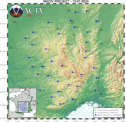
XP_2023 network station map (broadband temporary stations)
Network XP_2023
- Scientific goal : imaging of the crust and upper mantle (to a depth of 600-700 km) beneath the Massif Central, with deca-km resolution.
- 35 broadband stations (blue stars on the map) covering the whole of the Massif Central, to fill in the areas not (or poorly) covered by the permanent FR, G & RD networks (green circles on the map).
- Homogeneous coverage of the entire Massif, with a distance between stations of around 35 km.
- Instruments : T120QA and STS-2 broadband velocimeters, with Centaur acquisition systems belonging to the national Sismob pool of the Epos-France research infrastructure.
- Real-time data transmission to the Epos-Fr seismological data centre hosted by the OSUG via GSM modems.
- Remote supervision of network operation using the SyNApSE tool.
- Experiment duration : at least 3 years. Stations installed between 28/02/2023 (FR04A) and 24/01/2024 (FR11A). Dismantling scheduled in the first half of 2027.
- Estimated data size : 2.9 TB.
- Public data, distributed by the EPOS-France seismological data centre.
- This network is the French contribution to the European initiative AdriaArray.
Updated on 12 mars 2025


